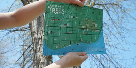
You can download and print the Fort Frances Trees Map here!
RRDS is working with the Town of Fort Frances, Fort Frances High School, and the Ministry of Natural Resources and Forestry to identify and label trees along selected active transportation routes in Fort Frances. Other partners include the Northwest Health Unit, the Rainy Lake Conservancy, and the Fort Frances Public Library Technology Center.
The purpose of this project is to educate the public, and get them thinking about trees. All trees on municipal property in Fort Frances are being mapped by Fort Frances High School and Youth Stewardship Rangers using GPS equipment. The original idea was to create a database of all the municipal trees with species, height, and diameter recorded. Since that time, the project has morphed to include an interactive web application of town trees based on iTree software developed in the United States. This program actually computes the annual Canadian dollar economic value of each tree in terms of energy savings, pollution abatement, carbon sequestration and storm water reduction. You can also recommend your private trees to be added to the database.
A walking map has also been created. Twelve Canadian trees now have small signs attached to them, showing the tree's common, scientific, and Ojibway names. The signs are minimally invasive, and will allow the trees to grow for 2 to 3 years before the sign needs to be inspected, and possibly adjusted or replaced. You can obtain your own copy of this map at the Fort Frances Museum, Library or Tourist Information Centre.
Work began with Grade 11 and 12 students at the end of the 2015-16 school year, continued on with the Youth Stewardship Rangers during the summer of 2015, and will continue with Fort Frances High School students during future school years. The Stewardship Rangers will be adding to the database this summer.